


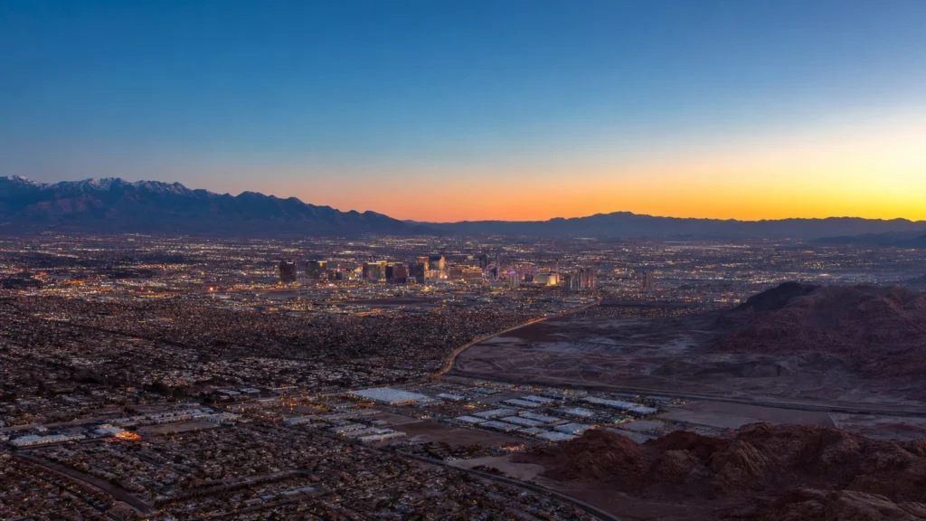
Las Vegas is in the U.S. state of Nevada, near the state’s southern tip, where it serves as the seat of Clark County. The city sits in the Mojave Desert, filling a wide, mountain-ringed basin called the Las Vegas Valley at about 2,000 feet above sea level, with GPS coordinates near 36.17 degrees North, 115.14 degrees West. One quirk trips up almost everyone: the famous Las Vegas Strip is not actually inside the city limits.
Las Vegas in one definition: Las Vegas is the largest city in Nevada and the seat of Clark County, located in the Mojave Desert of the state’s southern tip. It occupies the Las Vegas Valley, a desert basin about 2,000 feet above sea level and surrounded by mountains, in the Pacific Time Zone of the American Southwest.
- State and county: Las Vegas is in southern Nevada and is the county seat of Clark County.
- Region: It lies in the Mojave Desert of the American Southwest, in the Pacific Time Zone.
- Coordinates and elevation: About 36.17 degrees N, 115.14 degrees W, roughly 2,000 feet above sea level.
- The Strip surprise: Most of the Strip is in Paradise and Winchester, not the city of Las Vegas.
- Drive-in distances: About 270 miles from Los Angeles, 300 from Phoenix, and 420 from Salt Lake City.
What’s in This Guide
- Where Is Las Vegas? State, County, and Region
- The Las Vegas Valley: Desert, Elevation, and Mountains
- Las Vegas vs. the Strip: Why the Strip Isn’t in the City
- How Far Is Las Vegas From Major Cities?
- The Las Vegas Metro Area: Cities and Neighborhoods
- Getting to and Around Las Vegas
- Frequently Asked Questions
- Related Las Vegas Guides
Where Is Las Vegas? State, County, and Region
Las Vegas sits in the far southern tip of Nevada, in the American Southwest. It is the most populous city in the state and the administrative seat of Clark County, the county that covers the entire southern point of Nevada where it meets California and Arizona.
On a map, the city falls at roughly 36.17 degrees North latitude and 115.14 degrees West longitude. That places it in the Pacific Time Zone, on the same clock as Los Angeles and San Diego, observing Pacific Standard Time in winter and Pacific Daylight Time in summer. The city of Las Vegas itself covers about 135 square miles of land, though the developed metro area sprawls well beyond those official boundaries.
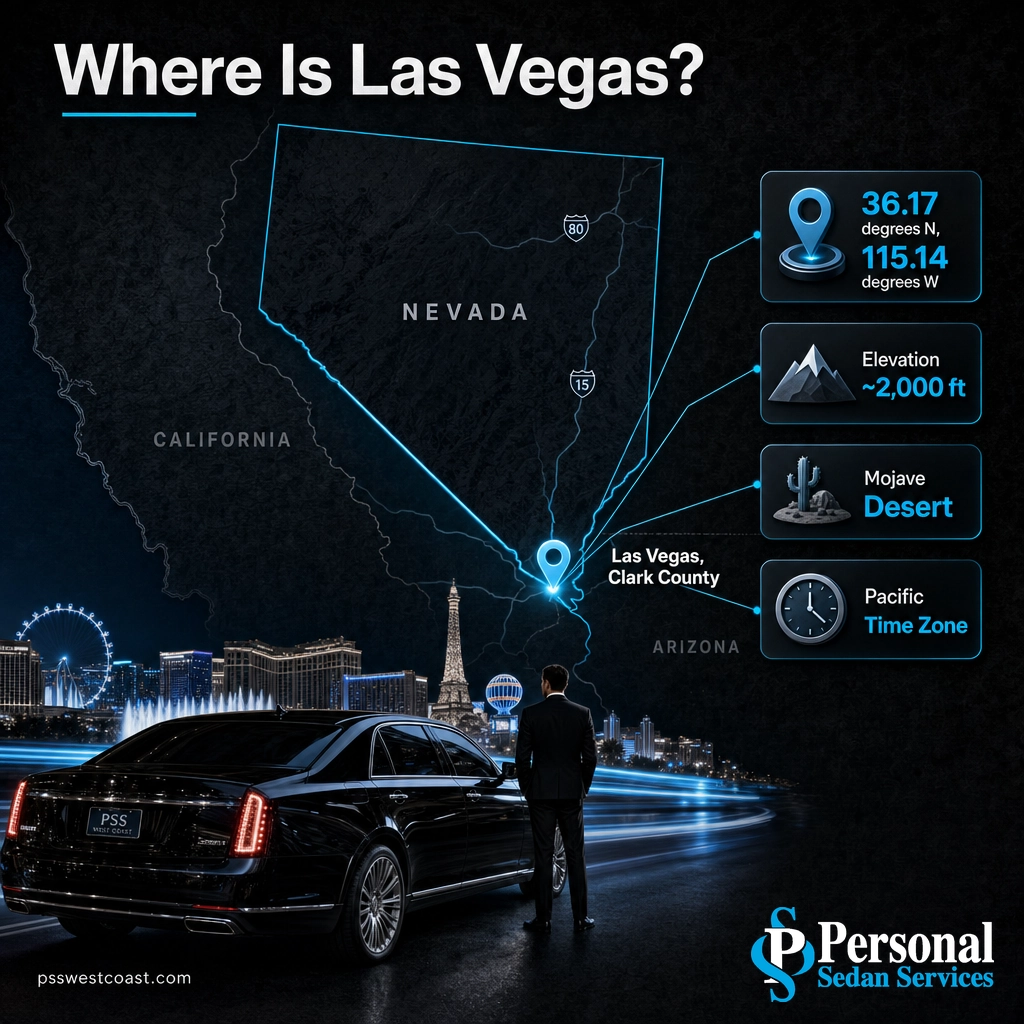
Because Las Vegas is a true desert city, its geography is defined more by what surrounds it than by any river or coastline. There is no major waterway running through downtown and no ocean nearby. Instead, the city is boxed in on nearly every side by mountains and open Mojave Desert, which is a big part of why the valley developed the compact, self-contained feel it has today.
| Geographic fact | Las Vegas |
|---|---|
| State | Nevada (southern tip) |
| County | Clark County (county seat) |
| Region | American Southwest / Mojave Desert |
| Coordinates | ~36.17° N, 115.14° W |
| Elevation | ~2,000 ft (610 m) above sea level |
| Time zone | Pacific Time (PST / PDT) |
To see exactly how the city fits into its desert basin, this map centers on Las Vegas and its surrounding valley:
Source: U.S. Census Bureau QuickFacts, Las Vegas city | Las Vegas Valley reference on Wikipedia
The Las Vegas Valley: Desert, Elevation, and Mountains
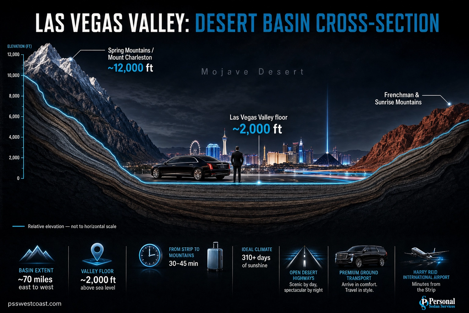
The technical answer to “where is Las Vegas” is the Las Vegas Valley, a roughly bowl-shaped basin in the Mojave Desert. The valley floor sits around 2,000 feet above sea level, and the mountains that ring it climb far higher, which gives the region its dramatic horizon in every direction.
Here is how the valley is framed:
- To the west: the Spring Mountains, crowned by Charleston Peak (Mount Charleston), which rises to nearly 12,000 feet and often holds snow while the valley floor stays warm.
- To the east: Frenchman Mountain and Sunrise Mountain, the reddish ridge line most visible from the Strip and downtown.
- To the south and northwest: lower desert ranges and open Mojave terrain that eventually give way to Red Rock Canyon and the road toward California.
This elevation matters more than most visitors expect. At 2,000 feet in a high desert, Las Vegas is dry, sunny, and hot in summer, but nights cool off quickly and winters are mild rather than tropical. The same mountains that create the scenery also create a rain shadow, keeping annual rainfall low and skies clear for most of the year.
Ecologically, the whole basin is part of the Mojave Desert, the same desert whose signature plant, the Joshua tree, grows in the higher elevations around the valley’s edges. That desert setting is why the Hoover Dam and Lake Mead, just southeast of the city, became so important: they supply the water and power that let a metro area of more than two million people thrive in an arid basin.
Source: National Park Service, Mojave Desert ecology | Spring Mountains reference on Wikipedia
Las Vegas vs. the Strip: Why the Strip Isn’t in the City
Here is the single most misunderstood fact about the city’s geography: most of the Las Vegas Strip is not inside the city of Las Vegas at all. The great majority of the famous resort corridor, the casinos, and the airport sit just south of the city limits in two unincorporated towns, Paradise and Winchester.
Myth: “Everything on the Strip is in the city of Las Vegas.” Reality: The Strip’s biggest resorts, Harry Reid International Airport, and the University of Nevada, Las Vegas all sit in Paradise, an unincorporated town, not the incorporated city of Las Vegas. Casino interests helped establish Paradise as a separate town in 1950 specifically to keep the city from annexing that valuable land. Every address there still reads “Las Vegas, NV,” which is exactly why almost no one notices.
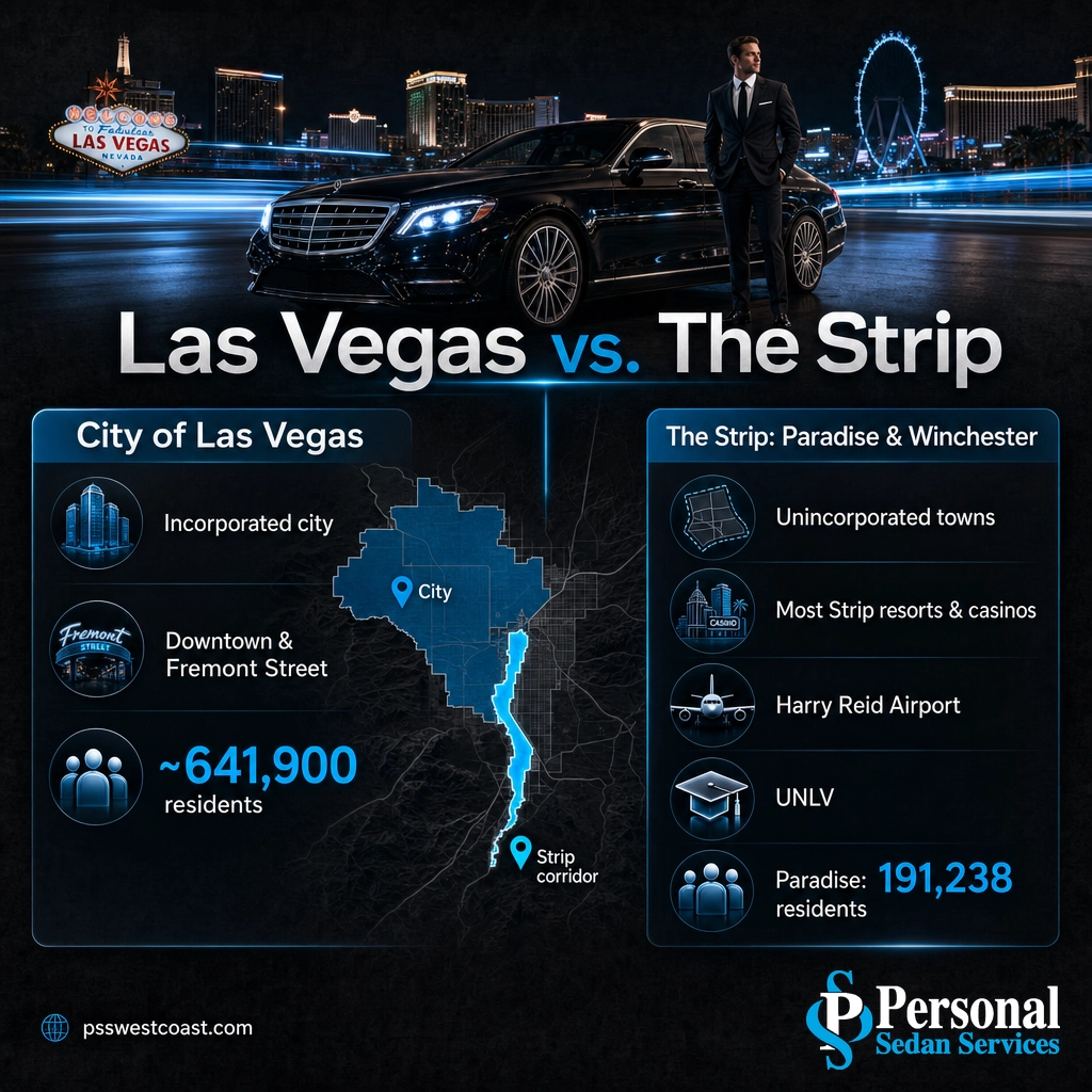
This is not a technicality that only mapmakers care about. It explains why the “population of Las Vegas” can look surprisingly small, and why the city proper and the tourist Strip feel like two different worlds. The table below sorts out which is which.
| Feature | City of Las Vegas | The Strip (Paradise & Winchester) |
|---|---|---|
| Legal status | Incorporated city | Unincorporated towns in Clark County |
| What’s there | Downtown, Fremont Street, government, older neighborhoods | Most Strip mega-resorts and casinos |
| Airport | Not in city limits | Harry Reid International Airport (in Paradise) |
| University | Not in city limits | UNLV (in Paradise) |
| Mailing address | Las Vegas, NV | Also Las Vegas, NV |
So when someone asks “where is Las Vegas,” the honest answer has two layers: the city of Las Vegas is a specific incorporated municipality of about 640,000 people, while “Las Vegas” as most travelers mean it is the whole valley, Strip included. For a deeper breakdown of who governs what, these facts about Paradise, Nevada walk through the arrangement in full.
Source: U.S. Census Bureau QuickFacts, Paradise CDP | Paradise, Nevada reference on Wikipedia

How Far Is Las Vegas From Major Cities?
One reason Las Vegas grew into a destination is its position within a day’s drive of Southern California and the wider Southwest. Interstate 15 runs straight through the valley, linking it to Los Angeles in one direction and Salt Lake City in the other, while U.S. 93 connects it toward Phoenix. The approximate driving distances below explain why so many visitors arrive by car.
Approximate driving distance to Las Vegas (miles)
Approximate driving distances via Interstate 15 and U.S. 93. Actual mileage varies by route and starting point.
| From | Direction | Approx. distance | Approx. drive time |
|---|---|---|---|
| Los Angeles, CA | Northeast via I-15 | ~270 miles | ~4 hours |
| San Diego, CA | Northeast via I-15 | ~330 miles | ~5 hours |
| Phoenix, AZ | Northwest via US-93 | ~300 miles | ~5 hours |
| Salt Lake City, UT | Southwest via I-15 | ~420 miles | ~6 hours |
| St. George, UT | Southwest via I-15 | ~120 miles | ~2 hours |
Those distances are also why a comfortable, chauffeured ride can be the difference between arriving fresh and arriving frazzled. If you are coming in from Southern California, our Los Angeles to Las Vegas car service covers the I-15 run door to door, and we run the same private routes from San Diego, Phoenix, Riverside, and Bakersfield.
See Long-Distance Routes to Las Vegas
Source: Federal Highway Administration interstate route data
The Las Vegas Metro Area: Cities and Neighborhoods
“Las Vegas” is really a cluster of cities, towns, and master-planned communities spread across the valley. The metro area, essentially all of Clark County, is home to more than two million people, far larger than the city proper. Understanding the pieces makes the whole valley easier to navigate.
The main components of the valley include:
- City of Las Vegas: downtown, the Fremont Street Experience, and older residential neighborhoods in the north-central valley.
- Paradise and Winchester: the unincorporated towns holding the Strip, the airport, and UNLV.
- Henderson: the valley’s second-largest city, to the southeast, known for master-planned suburbs.
- North Las Vegas: a separate incorporated city on the valley’s north side.
- Summerlin, Enterprise, Spring Valley, and Centennial Hills: large communities filling out the west and south.
If you want the full lay of the land, our Las Vegas neighborhood guide maps out how these areas connect, and separate guides cover North Las Vegas and the outer communities in detail. Wherever you are staying, a local Las Vegas car service can move you between them without the guesswork of rideshare surge pricing.
Source: U.S. Census Bureau QuickFacts, Clark County
Getting to and Around Las Vegas
Most visitors arrive one of two ways: by air into Harry Reid International Airport, which sits in Paradise just a few minutes from the south end of the Strip, or by car down Interstate 15. Both put you within easy reach of the resort corridor, but the valley’s real distances can surprise first-timers, since a hotel that looks close on the Strip can still be a long, hot walk away.
Once you are on the ground, the Strip, downtown, and the outlying neighborhoods are spread across a basin roughly 20 miles across. That scale is why a professional, licensed driver is often worth it: instead of guessing at rideshare availability after a show or a late flight, a prearranged local transportation service is already waiting. From the moment you land, our Harry Reid airport shuttle and pickup service takes you straight to your hotel in a clean, chauffeured vehicle.
Whether you are a visitor learning the valley for the first time or a local who would rather not drive the Strip on a Friday night, knowing where Las Vegas actually is, and how its pieces fit together, makes every trip smoother.
Book Your Ride: (702) 248-7706
Frequently Asked Questions
What state is Las Vegas in?
Is the Las Vegas Strip in the city of Las Vegas?
What are the GPS coordinates of Las Vegas?
How far is Las Vegas from Los Angeles?
What desert is Las Vegas in?
Related Las Vegas Guides
- Las Vegas Neighborhood Guide: how the valley’s districts and master-planned communities fit together.
- Paradise, Nevada Facts: the unincorporated town that holds the Strip, the airport, and UNLV.
- North Las Vegas Guide: the separate city on the valley’s north side.
- Los Angeles to Las Vegas Car Service: the I-15 drive-in route, chauffeured door to door.
Sources & Methodology
Geographic facts in this guide (state, county, coordinates, elevation, population, and the boundaries of the city versus the Strip) are drawn from primary public data. Driving distances are approximate and reflect common interstate routes; actual mileage and time vary by starting point, traffic, and road conditions.