


Quick answer: Valley of Fire State Park is about 55 miles northeast of Las Vegas, roughly a one-hour drive. The fast route is I-15 north to Exit 75, then Valley of Fire Highway (NV-169) east about 15 miles to the west entrance. A longer scenic route runs along Lake Mead’s Northshore Road and takes closer to 1.5 hours. At an hour each way, it is one of the easiest and most rewarding day trips out of the city.
If you are searching “how far is Valley of Fire from Las Vegas,” you are almost certainly planning a day trip to the state’s most photographed red-rock desert, and the good news is that it is close. Nevada’s oldest state park sits about an hour northeast of the Strip, close enough to leave after breakfast and be home for dinner, yet far enough that the glowing Aztec sandstone feels a world away from the casino floor. This guide gives you the exact distance and drive time, the fast route and the scenic one, the park fees and hours, what to see when you arrive, and the most comfortable way to cover the miles.
- Distance: about 55 miles from the Las Vegas Strip to the west entrance, roughly a one-hour drive.
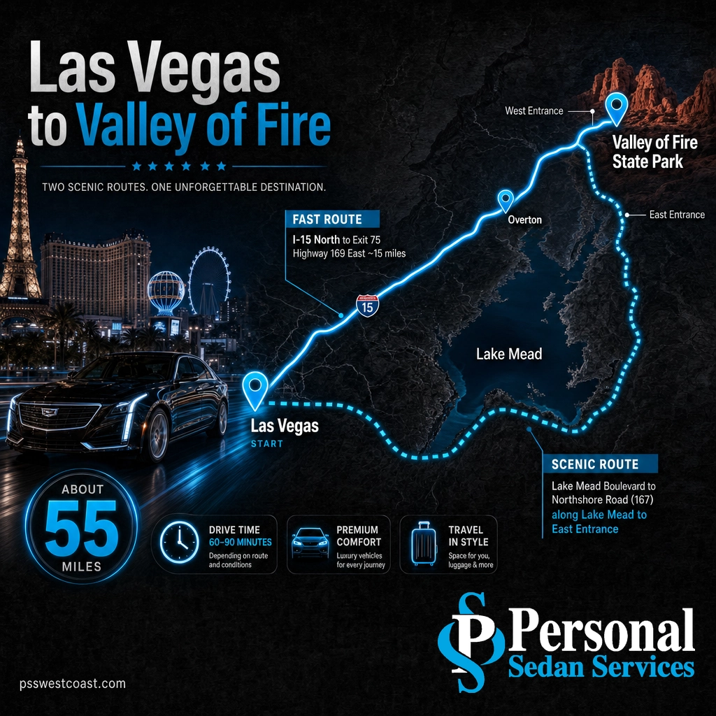
- Fast route: I-15 north to Exit 75, then Valley of Fire Highway (NV-169) east about 15 miles.
- Scenic route: Lake Mead Boulevard to Northshore Road (NV-167) along the lake to the east entrance, about 1.5 hours.
- Cost and hours: $10 per Nevada vehicle, $15 out-of-state, open daily sunrise to sunset.
- Day trip: absolutely. Two hours of round-trip driving plus three to five hours in the park makes a full, easy day.
- Heat warning: summer temperatures routinely top 110 degrees with little shade, so the park is best from October through April.
- For families and groups, many travelers let a private chauffeur drive so the whole car can watch the desert instead of the road.

What’s in This Guide
- How Far Is Valley of Fire from Las Vegas, Exactly?
- Ways to Get from Las Vegas to Valley of Fire
- The Drive: Best Route and the Scenic Alternative
- What to See at Valley of Fire and Along the Way
- How Valley of Fire Compares to Other Las Vegas Day Trips
- Can You Do Valley of Fire as a Day Trip from Las Vegas?
- Skip the Drive: Let Us Take You to Valley of Fire
- Frequently Asked Questions
- Related Las Vegas Travel Guides
How Far Is Valley of Fire from Las Vegas, Exactly?
Valley of Fire State Park lies about 55 miles northeast of the Las Vegas Strip, a drive of roughly 55 minutes to an hour in normal traffic. The park spreads across about 40,000 acres of brilliant red Aztec sandstone in the Mojave Desert, and its main west entrance opens off Valley of Fire Highway, the state road that branches east from Interstate 15.
Exact mileage depends on where you start and which entrance you use, so you will see figures from 50 to 60 miles quoted around the web. From the heart of the Strip to the west entrance fee station, about 55 miles and one hour is the reliable planning number. The table below anchors the key figures.
| Measure | Las Vegas to Valley of Fire | What it means |
|---|---|---|
| Driving distance | ~55 miles | From the Strip to the west entrance. Roughly 50 to 60 miles depending on your exact start. |
| Drive time | ~1 hour | Normal traffic on the fast route. The scenic Lake Mead route runs closer to 1.5 hours. |
| Fast route | I-15 N to Exit 75, then NV-169 E | The quickest way in, used by most visitors heading to the west entrance. |
| Day-use fee | $10 NV / $15 out-of-state | Per vehicle, per Nevada State Parks. Open daily sunrise to sunset. |

Source: Google Maps driving directions, Las Vegas to Valley of Fire | Nevada State Parks: Valley of Fire
Ways to Get from Las Vegas to Valley of Fire
Because there is no train or shuttle line to the park and no services inside it, getting to Valley of Fire comes down to four real options. Here is an honest look at each, from cheapest to most comfortable.
| Option | Time | Rough cost | Best for |
|---|---|---|---|
| Drive yourself | ~1 hr each way | Fuel plus the park fee | Flexibility and the freedom to stop at Lake Mead, Overton, or any pullout along the way. |
| Guided group tour | Full day | $$ per seat | Visitors with no car. Often bundled with Hoover Dam, but on a fixed schedule and a shared bus. |
| Rideshare | Matches driving | $$$ and risky | Rarely practical. A long one-way desert fare runs high, cell service is spotty, and no driver is waiting to bring you back. |
| Private car service (us) | ~1 hr each way | $$ flat quote | Families and groups. A professional chauffeur drives, waits or returns on your schedule, and everyone relaxes. |
The rideshare option is the one that catches people out. Dropping a car at a remote state park with no reliable signal means you may stand at the entrance a long time hoping a return ride appears. For a day at Valley of Fire, driving yourself or booking a private car are the only two options that guarantee a ride home.
Book a Valley of Fire day trip with a private driver
The Drive: Best Route and the Scenic Alternative
There are two ways to reach Valley of Fire from Las Vegas, and they are genuinely different experiences. Most visitors take the fast highway route in and, if time allows, come home the scenic way along Lake Mead.
- The fast route (west entrance). Head north on I-15 out of the valley for about 35 miles to Exit 75. Turn east onto Valley of Fire Highway (NV-169) and follow it roughly 15 miles through open desert straight to the west entrance. This is the quickest way in, about an hour from the Strip.
- The scenic route (east entrance). Take Lake Mead Boulevard east to Northshore Road (NV-167) and follow it north along the edge of Lake Mead, through sweeping desert and mountain scenery, to the park’s east entrance. It adds roughly half an hour but is one of the prettiest drives in southern Nevada.
- Last gas and supplies. There is no fuel, food, or reliable cell service inside the park. Fill the tank and grab water before you leave the interstate. The Moapa Valley Travel Plaza at Exit 75 and the town of Overton are your nearest stops.
Pro tip: make it a loop. Drive in the fast way on I-15 to beat the morning, then leave the park through the east entrance and glide home down Northshore Road past Lake Mead in the afternoon light. You see twice the scenery for about 30 extra minutes.
Heat warning: Valley of Fire is one of the hottest places in Nevada. Summer temperatures routinely top 110 degrees with almost no shade, and the red rock radiates even more heat. Several visitors need rescue here every summer. Carry far more water than you think you need, hike early, and plan serious visits for October through April. In summer, treat it as a sunrise or late-afternoon stop only.
Source: Nevada State Parks: Valley of Fire directions and hours | Nevada 511 live road conditions
What to See at Valley of Fire and Along the Way
Valley of Fire earns the hour it takes to reach it. Established in 1935 as Nevada’s first state park, it packs ancient petroglyphs, petrified logs, and some of the most striking sandstone formations in the Southwest into a compact, drivable park. These are the highlights genuinely worth your time.
- The Fire Wave. The park’s signature view, a swirl of banded red and cream sandstone reached by a short 1.5-mile round-trip trail off Mouse’s Tank Road. Go early or late for the best light and the coolest temperatures.
- Atlatl Rock. A tall outcrop with a metal stairway up to one of the finest panels of ancient petroglyphs in the state, some carved more than 2,000 years ago.
- Elephant Rock and Arch Rock. Two easy-to-reach natural sandstone shapes near the east entrance, perfect for a quick photo stop without a long hike.
- White Domes and Mouse’s Tank Road. The scenic paved drive to the back of the park passes pastel domes and canyon walls, with the White Domes loop trail at the end.
The route in has its own worthwhile stops. The Lake Mead National Recreation Area flanks the scenic Northshore Road, and the nearby town of Overton is home to the Lost City Museum, which displays ancestral Puebloan artifacts recovered from the valley before Lake Mead was filled.
Source: Nevada State Parks: Valley of Fire | Travel Nevada: Valley of Fire State Park
How Valley of Fire Compares to Other Las Vegas Day Trips
Part of what makes Valley of Fire such an easy choice is where it sits on the map of Las Vegas day trips. It is farther than the quick Red Rock loop but far closer than the national parks, which keeps it squarely in the leave-after-breakfast range.
| Destination | Driving distance | Drive time |
|---|---|---|
| Red Rock Canyon | ~20 mi | ~30 min |
| Hoover Dam | ~35 mi | ~45 min |
| Valley of Fire | ~55 mi | ~1 hr |
| Death Valley (Furnace Creek) | ~120 mi | ~2 hr |
| Zion National Park | ~160 mi | ~2 hr 45 min |
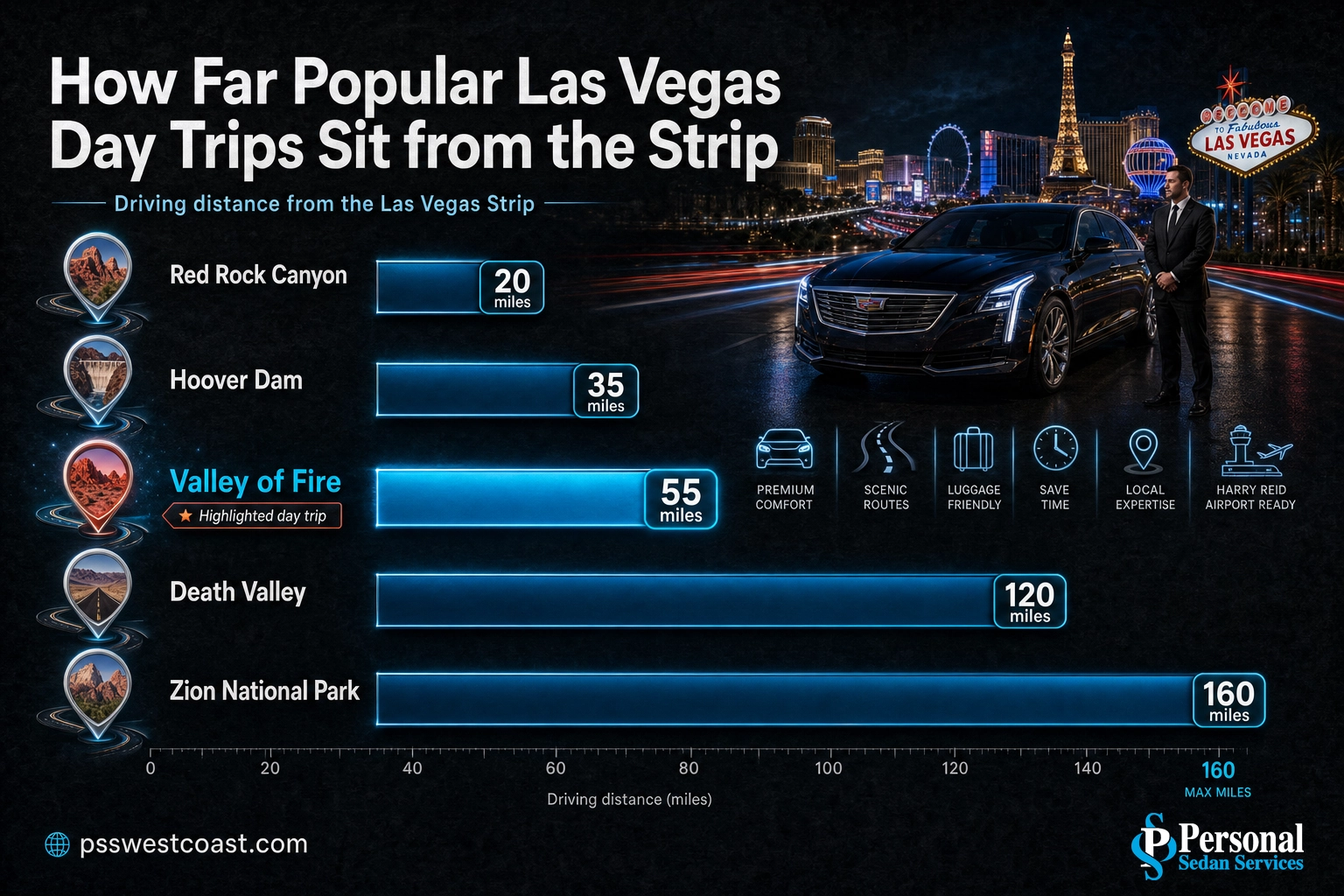
How Far Popular Las Vegas Day Trips Sit from the Strip
Approximate driving distance from the Las Vegas Strip to popular day-trip destinations. Source: Google Maps estimates.
For other close escapes, compare the quick desert loop at Red Rock Canyon or the engineering landmark at Hoover Dam, both even closer than Valley of Fire.
Source: Google Maps driving directions from Las Vegas

Can You Do Valley of Fire as a Day Trip from Las Vegas?
Yes, and it is one of the best. Valley of Fire is practically built to be a day trip from Las Vegas. Here is the simple math that makes it work.
The day-trip math: about one hour of driving each way is two hours round trip. Add three to five hours exploring the park, which is plenty of time for the Fire Wave, Atlatl Rock, and the scenic drive, and your whole outing runs five to seven hours. Leave at 8 a.m. and you are back in the city by mid-afternoon with daylight to spare.
Unlike Zion, Death Valley, or the Grand Canyon, which push four or more hours each way and really want an overnight, Valley of Fire never forces the choice. You can see its best in a relaxed day without rushing. The one thing to plan around is heat: in summer, shift your visit to early morning or late afternoon and keep it short, because the open red rock turns brutal by midday.
The honest takeaway is that the drive itself is the only downside, and it is a small one. Two hours behind the wheel through the desert, often in summer glare, is far more pleasant when someone else is driving and the whole group can watch the scenery instead of the center line.
Skip the Drive: Let Us Take You to Valley of Fire
The road to Valley of Fire is easy, but it is still two hours of desert driving, a remote park with no services, and summer heat pressing in through the glass. Whoever is behind the wheel spends the day watching the road instead of the red rock, then faces the drive home tired after hours in the sun.
A private chauffeured car takes all of that off your plate. A professional driver handles the entire route in a clean, late-model sedan, SUV, or van, drops your group right at the trailheads, and is there waiting when you are ready to leave. No parking, no navigating, no worrying about fuel or a return ride, and no one in your party stuck as the designated driver.
See our group day-trip transportation
Personal Sedan Services runs Las Vegas day trips every day with licensed, background-checked chauffeurs and a full fleet from executive sedans to group vans. Whether it is a couple chasing the Fire Wave at sunrise or a family of six out for the afternoon, a professional chauffeur handles the miles so you can simply enjoy the desert.
Frequently Asked Questions
How far is Valley of Fire from Las Vegas?
How long does it take to drive from Las Vegas to Valley of Fire?
Can you visit Valley of Fire as a day trip from Las Vegas?
How much does it cost to enter Valley of Fire State Park?
What is the best route from Las Vegas to Valley of Fire?
Related Las Vegas Travel Guides
- How far Red Rock Canyon is from Las Vegas – the quick 30-minute desert loop west of the city.
- How far Hoover Dam is from Las Vegas – the engineering landmark 45 minutes southeast.
- How far Zion National Park is from Las Vegas – the Utah red-rock giant about 2.5 hours north.
- How far Death Valley is from Las Vegas – the hottest national park, about two hours west.
- How far the Grand Canyon is from Las Vegas – the classic long day trip or overnight.
- How far Arizona is from Las Vegas – every Arizona destination, from the state line to Phoenix.
Sources and Methodology
Driving distances and drive times from Las Vegas to Valley of Fire State Park are approximate, based on Google Maps directions from the Strip along the primary routes, and vary with traffic, weather, and your exact starting point and entrance. The fast route is I-15 north to Exit 75, then Valley of Fire Highway (NV-169) east to the west entrance, about 55 miles and one hour. The scenic alternative follows Lake Mead’s Northshore Road (NV-167) to the east entrance and runs closer to 1.5 hours. Park fees, hours, size, and the 1935 founding date come from Nevada State Parks. Attraction and route details reference Travel Nevada, the National Park Service for Lake Mead National Recreation Area, and the Lost City Museum. Day-trip distances to other destinations are Google Maps estimates.
