


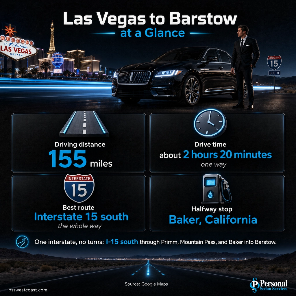
Quick answer: Barstow, California is about 155 miles from Las Vegas, a straight shot southwest on Interstate 15 that takes roughly 2 hours 20 minutes in normal traffic. There are no turns to worry about, but this is the main Los Angeles to Las Vegas corridor, so weekend and holiday backups can add real time. There is no commercial airport in Barstow, so nearly everyone makes this trip by road.
If you are searching “how far is Barstow from Las Vegas,” you are usually planning one of two things: a quick run out to Barstow itself, or the long haul between Las Vegas and Southern California with Barstow as the halfway stop. Either way the answer is the same. Barstow is about 155 miles from Las Vegas, roughly a two hour and twenty minute drive straight down Interstate 15 through the Mojave Desert. It is one of the easiest routes to navigate out of Las Vegas, a single interstate the whole way, but the timing and the stops are what separate a smooth trip from a long, hot slog.
- Distance: about 155 miles by road from Las Vegas to Barstow, California.
- Drive time: about 2 hours 20 minutes one way in normal traffic, or under 5 hours round trip.
- Best route: Interstate 15 south the entire way, through Primm, Mountain Pass, and Baker. No turns, no alternatives worth taking.
- Halfway point: Baker, California, home of the World’s Tallest Thermometer, is the main fuel, food, and rest stop.
- Traffic reality: this is the Los Angeles to Las Vegas corridor. Sunday afternoons, Fridays, and holiday weekends can add an hour or more.
- A day trip is very doable. For the long SoCal drive, many travelers let a private chauffeur handle the wheel so the desert miles become rest time.
What’s in This Guide
- How Far Is Barstow from Las Vegas, Exactly?
- Ways to Get from Las Vegas to Barstow
- The Drive: Best Route and What to Expect
- Best Stops on I-15 Between Las Vegas and Barstow
- What to Do Once You Reach Barstow
- Can You Do Barstow as a Day Trip from Las Vegas?
- Skip the Drive: Let Us Take You
- Frequently Asked Questions
- Related Las Vegas Travel Guides
How Far Is Barstow from Las Vegas, Exactly?
Barstow is about 155 miles from Las Vegas by road, and unlike most desert destinations, the driving distance is close to the straight-line distance because Interstate 15 runs almost directly between the two. That works out to roughly two hours and twenty minutes of driving in normal conditions. The route never leaves I-15, so there are no turns to miss and no faster back way. What changes the trip is not the mileage, it is the traffic, because this is the single busiest highway between Southern California and Las Vegas.
| Measure | Las Vegas to Barstow | What it means |
|---|---|---|
| Driving distance | ~155 miles | The real road distance, almost all of it on Interstate 15. |
| Drive time (one way) | ~2 hr 20 min | Normal traffic. Budget 3+ hours on busy weekends and holidays. |
| Best route | Interstate 15 south | One interstate the whole way. No turns, no alternatives worth taking. |
| Halfway stop | Baker, CA (~62 mi from Barstow) | The main fuel, food, and restroom break between the two. |
There is no commercial airport in Barstow and no direct passenger train from Las Vegas, so for essentially every traveler this is a driving trip. That makes two things worth getting right before you leave: when you go, and where you stop.
Source: Google Maps driving directions, Las Vegas to Barstow
Ways to Get from Las Vegas to Barstow
Because there is no Barstow airport, the real choice is how you cover the 155 miles of I-15, not whether to drive them. Here is an honest look at every option that actually works, from cheapest to most comfortable.
| Option | Time | Rough cost | Best for |
|---|---|---|---|
| Drive yourself | ~2 hr 20 min | Fuel plus your time | Flexibility, solo travelers and couples comfortable with the long desert drive. |
| Intercity bus | ~2.5 to 3 hr | $ (lowest) | Budget travelers without a car who can work around a fixed station-to-station schedule. |
| Rideshare | ~2 hr 20 min | $$$ (surge-prone) | Rarely practical. A 155-mile one-way fare is expensive and hard to book, with no ride waiting for the trip back. |
| Private car service (us) | ~2 hr 20 min | $$ flat quote | Groups, families, and the full Las Vegas to Southern California haul. A professional chauffeur drives while you rest, work, or relax. |
Intercity carriers such as FlixBus and Greyhound run along the I-15 corridor and are the cheapest way to go if you do not have a car, though they run on their own schedule between set stops. Rideshare technically works but rarely makes sense at this distance: a one-way Uber or Lyft across the Mojave runs high and leaves you stranded for the return. For a group, or for anyone doing the longer Las Vegas to Los Angeles run with Barstow in the middle, a private chauffeured car is the option that turns the drive into downtime instead of a chore.
See our long-distance car service routes
The Drive: Best Route and What to Expect
The good news is that this is one of the simplest drives out of Las Vegas. You get on Interstate 15 heading south and you stay on it until Barstow. There is no scenic alternative that saves time and no confusing interchange to plan for. Here is how the drive breaks down.
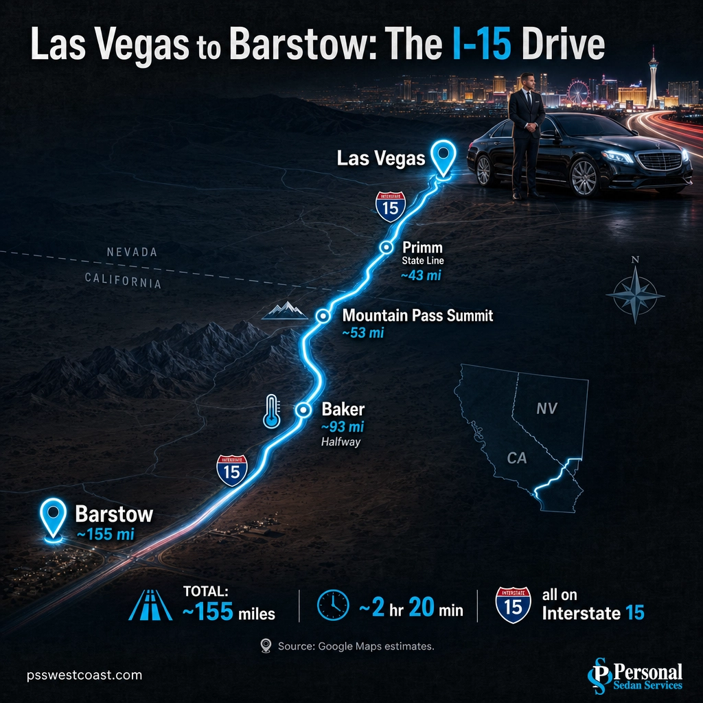
- Out of the Las Vegas valley to the state line. I-15 south takes you past the southern edge of the valley and out into open desert. About 43 miles in you reach Primm, the casino town straddling the Nevada and California border, the last easy stop before you leave the state.
- Over Mountain Pass. Just past Primm the freeway climbs to Mountain Pass, the high point of the drive at roughly 4,700 feet, then descends into the Ivanpah Valley alongside the Mojave National Preserve. This is the emptiest stretch, so watch your fuel gauge.
- Down through Baker and into Barstow. The freeway drops to Baker, the halfway service town, then runs southwest across the Mojave through Afton Canyon country and into Barstow, a Route 66 and railroad crossroads.
Fuel and service tip: Between Primm and Baker there are long gaps with no gas, food, or reliable cell service. Fill the tank before you leave Las Vegas or top off at Primm, carry water, especially in summer when Mojave temperatures routinely top 110 degrees, and download your route for offline use.
Traffic warning: Interstate 15 is the main artery between Las Vegas and Southern California, and it backs up predictably. Sunday afternoons and evenings, Friday getaways, and holiday weekends can turn the 2 hour 20 minute drive into three or four hours, with the worst crawls near the state line and Baker. When you can, travel mid-morning or on a weekday, and check road conditions before you go.
Source: Caltrans QuickMap live road conditions | Nevada 511 road conditions
Ride the Los Angeles to Las Vegas route with us
Best Stops on I-15 Between Las Vegas and Barstow
The drive itself is straight and stark, but a few genuine stops break up the miles and turn the desert crossing into part of the trip. Here they are in order as you head south from Las Vegas.
How Far Each Stop Sits from Las Vegas (I-15 South)
Approximate driving distance from Las Vegas to each I-15 waypoint. Source: Google Maps estimates.
- Primm, Nevada. The state-line town about 43 miles in, with casinos, a roller coaster, and the Primm Valley outlet stores. It is the last Nevada stop and a common fuel and stretch break.
- Zzyzx Road. One of the most photographed road signs in the West, marking a lonely exit into the Mojave National Preserve. The road leads to the old Soda Springs resort, now a university desert studies center, a quirky detour if you have time.
- Baker, California. The unofficial halfway point and the main service stop, home of the World’s Tallest Thermometer and the gateway to Death Valley. Fuel up, grab food, and use the restroom here, because services thin out again afterward.
- Afton Canyon. Nicknamed the “Grand Canyon of the Mojave,” this BLM-managed canyon sits just off I-15 between Baker and Barstow, one of the few places the usually dry Mojave River runs on the surface.
Source: Mojave National Preserve official site | National Weather Service Las Vegas climate records
What to Do Once You Reach Barstow
Barstow is a Mojave crossroads with more history than its highway-stop reputation suggests. Route 66 and the railroad built the town, and both still anchor what there is to see and do.
- Outlet shopping. The Tanger Outlets and the neighboring Barstow Factory Outlets sit right off I-15, the reason many Las Vegas and Los Angeles travelers plan the stop in the first place.
- Route 66 Mother Road Museum. Housed in the historic Casa del Desierto Harvey House depot, it tells the story of the Mother Road through Barstow, alongside the Western America Railroad Museum in the same building.
- Calico Ghost Town. About 10 miles northeast, a restored 1880s silver-mining town and San Bernardino County regional park, one of the area’s top family attractions.
- Rainbow Basin. A BLM natural area north of town known for its dramatically banded, folded rock formations, a scenic drive and photography favorite.
Source: Calico Ghost Town Regional Park, San Bernardino County | Route 66 Mother Road Museum
Explore the route with a private chauffeur
Can You Do Barstow as a Day Trip from Las Vegas?
Yes, and comfortably. At about 2 hours 20 minutes each way, a Las Vegas to Barstow round trip is under five hours of driving, which leaves a full day for the outlets, the museums, or a run out to Calico Ghost Town. Compared to the bigger desert day trips out of Las Vegas, Barstow is one of the shorter and easier ones.
The day-trip math: Leave Las Vegas at 8 or 9 a.m., spend four to five hours in Barstow and around Calico, and you are back before dinner with time to spare. The only thing that reliably breaks the plan is traffic, so avoid heading home on a Sunday afternoon when the whole Los Angeles to Las Vegas corridor is trying to do the same thing.
The trip gets more interesting when Barstow is not the destination but the midpoint. If you are traveling the full Las Vegas to Southern California route, Barstow is almost exactly halfway, which is why it is the natural place to break the drive. That longer haul, four to five hours of desert interstate, is where handing the wheel to a professional driver pays off most.

Skip the Drive: Let Us Take You
Interstate 15 across the Mojave is long, hot, and monotonous, and on a busy weekend it is bumper to bumper for miles. Whether Barstow is your stop or your halfway point on the way to Los Angeles, the driving pain is the same: hours of open desert, no one in the car free to relax, gas and rest stops to plan, and heavy traffic waiting on both ends of the weekend.
A private chauffeured car takes all of that off your plate. A professional driver handles the entire I-15 run in a luxury sedan, SUV, or van, so your group travels together, stops where you want, and arrives rested instead of drained. It is the most comfortable way to cover the distance, and for the full Las Vegas to Southern California drive it is the option most people wish they had known about sooner.
Explore our luxury transportation options
Personal Sedan Services runs the Las Vegas to Southern California corridor every day, with clean, late-model vehicles and licensed, background-checked chauffeurs. Barstow sits right on our Los Angeles and Riverside routes, so we can take you there, meet you there, or fold it into a longer trip.
Book your Barstow or SoCal ride
Frequently Asked Questions
How far is Barstow from Las Vegas?
How long does it take to drive from Las Vegas to Barstow?
Can you drive from Las Vegas to Barstow as a day trip?
What is the best route from Las Vegas to Barstow?
Is it worth stopping in Barstow between Las Vegas and Los Angeles?
Related Las Vegas Travel Guides
- How far Los Angeles is from Las Vegas – the full I-15 corridor drive, with Barstow as the halfway point.
- How far Riverside is from Las Vegas – another SoCal drive that runs down the same interstate.
- How far Bakersfield is from Las Vegas – the route that turns off at Barstow onto CA-58.
- How far San Diego is from Las Vegas – the longer Southern California coastal haul.
- How far St. George, Utah is from Las Vegas – the I-15 drive in the other direction.
- Best day trips from Las Vegas – the full menu of drives worth taking.
Sources and Methodology
Driving distance and drive time from Las Vegas to Barstow are approximate, based on Google Maps directions along Interstate 15; actual times vary with traffic, weather, and stops, and the I-15 Los Angeles to Las Vegas corridor is prone to heavy weekend and holiday congestion. Waypoint distances to Primm, Mountain Pass, and Baker are approximate Google Maps figures. The World’s Tallest Thermometer in Baker stands 134 feet to commemorate the 134 degree Fahrenheit reading recorded in Death Valley in 1913, still the highest air temperature reliably recorded on Earth per NOAA and the National Weather Service. Attraction details reference the Mojave National Preserve (National Park Service), San Bernardino County Regional Parks, the Bureau of Land Management, and the Route 66 Mother Road Museum. Road-condition guidance references Caltrans QuickMap and Nevada 511.