


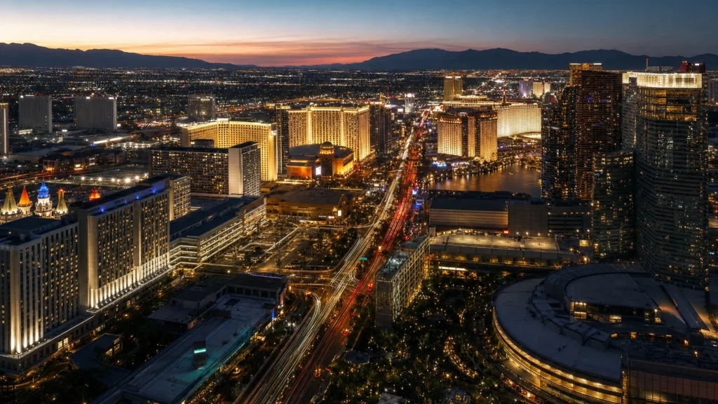
The Las Vegas Strip is about 4.2 miles (6.8 km) long. It is the stretch of Las Vegas Boulevard South that holds the famous resorts, running roughly from Sahara Avenue in the north to the Welcome to Fabulous Las Vegas sign in the south. Walking it end to end takes most people 90 minutes to two hours nonstop.
If you are planning a trip, the honest answer matters more than the number: the Strip looks compact on a map, but at 4.2 miles it is longer than it appears, the resorts are enormous, and Las Vegas summer heat regularly tops 100 degrees. Below is exactly how long the Strip is, where it starts and ends, a map, real walk times between the major resorts, and when it makes sense to ride instead of walk.
- Length: The Las Vegas Strip is about 4.2 miles (6.8 km), measured along Las Vegas Boulevard South.
- Start and end: Roughly Sahara Avenue (or the Strat) in the north to the Welcome to Fabulous Las Vegas sign, near Russell Road, in the south.
- Not in the city: Most of the Strip is in unincorporated Paradise and Winchester in Clark County, not the city of Las Vegas.
- Walk time: About 90 minutes to 2 hours end to end at a steady pace with no stops. With sights and food, budget a half day or more.
- Reality check: Casinos are huge and the heat is real. Free trams, the monorail, and a private car cover the long stretches far faster.
What’s in This Guide
- How Long Is the Las Vegas Strip?
- Where the Strip Starts and Ends (Map)
- How Long It Takes to Walk the Strip
- Walk Times Between the Major Resorts
- Strip vs. Las Vegas Boulevard vs. Downtown
- Should You Walk the Strip or Ride?
- Tips for Getting Around the Strip
- Common Questions About the Length of the Strip
- Related Las Vegas Guides
How Long Is the Las Vegas Strip?
The Las Vegas Strip is approximately 4.2 miles (6.8 kilometers) long. That measurement follows Las Vegas Boulevard South through the resort corridor, the section lined with the hotels, casinos, and attractions most visitors picture when they think of Las Vegas.
That 4.2-mile figure is the number nearly every travel guide, tour operator, and local uses. It is worth knowing that Las Vegas Boulevard itself is far longer than the Strip: the full boulevard stretches well beyond the resort corridor in both directions. When people say “the Strip,” they mean only the roughly four-mile entertainment stretch, not the entire road.

Source: Las Vegas Strip on Wikipedia
Where the Strip Starts and Ends (Map)
There is no single legal line that defines the Strip, so the exact endpoints depend on who you ask. The widely accepted boundaries are:
- North end: Sahara Avenue is the commonly cited northern boundary. Many travel guides extend it a little farther north to the Strat tower, about four tenths of a mile past Sahara.
- South end: The Welcome to Fabulous Las Vegas sign, sitting on a median just south of Russell Road, marks the classic southern boundary. Clark County notes that some sources use Russell Road itself as the southern terminus.
Common surprise: the Strip is not inside the city of Las Vegas. Most of it lies in the unincorporated towns of Paradise and Winchester in Clark County, immediately south of the Las Vegas city limits. The mailing address says Las Vegas, but the resort corridor is technically outside city lines.
Source: Las Vegas Strip on Wikipedia | Las Vegas Boulevard reference
How Long It Takes to Walk the Strip
Walking the full Strip from one end to the other takes most people about 90 minutes to two hours at a steady pace with no stops. A brisk walker moving at 3.5 miles per hour can cover it closer to 75 to 90 minutes; a relaxed 2-mile-per-hour stroll pushes past two hours before a single photo.
That nonstop number is almost never what actually happens. A useful rule of thumb from local walking guides: add 15 to 20 minutes of unplanned stop time for every mile you walk, before you factor in any real sightseeing. Photos at the fountains, a drink, a show, or lunch each add their own block of time. To walk the Strip and genuinely see it, plan for a half day, and a full day if you want to go inside the big resorts.
The mistake almost every first-timer makes: “It all looks close, so we will just walk everywhere.” Two things break that plan. First, scale, the resorts are massive, and two hotels that look next door can be a 15-minute walk apart once you account for the buildings between them. Second, heat. Las Vegas averages a normal high of 104.5 degrees in July, and the open, shade-free sidewalks make a midday summer walk genuinely draining. Pace yourself, hydrate, and use the trams or a car for the long hops.
Source: NOAA U.S. Climate Normals

Walk Times Between the Major Resorts
The full-Strip number is useful, but most visitors care about shorter hops: how long is it really from your hotel to dinner or a show? Here are typical walking times between well-known resorts and landmarks, at a normal pace and before crowds. Remember that casinos are enormous, so add 5 to 10 minutes of interior walking before you even reach the sidewalk.
| Stretch | Typical walk time | Notes |
|---|---|---|
| Mandalay Bay to Excalibur | 10–14 min | Free tram connects Mandalay Bay, Luxor, and Excalibur |
| Excalibur to MGM Grand | 13–18 min | Via New York-New York and the pedestrian bridges |
| MGM Grand to Bellagio | 15–20 min | Or take the free Aria Express tram in about 8 min |
| Bellagio to Caesars Palace | 10–15 min | Both resorts are set back from the road |
| Caesars to The Venetian | 13–20 min | Past the LINQ and Harrah’s |
| The Venetian to Wynn | 10–15 min | North Strip gaps get longer |
| Wynn to the Strat | 30–45 min | Long, low-density stretch, better by car or monorail |
| Full Strip, end to end | 90–120 min | 4.2 miles, nonstop, no sightseeing |
Walk times are typical estimates compiled from Las Vegas walking guides, at a steady pace before crowds and casino interiors. Free trams (Mandalay Bay to Excalibur, and Aria Express between Park MGM and Bellagio) and pedestrian bridges shorten several of these hops.
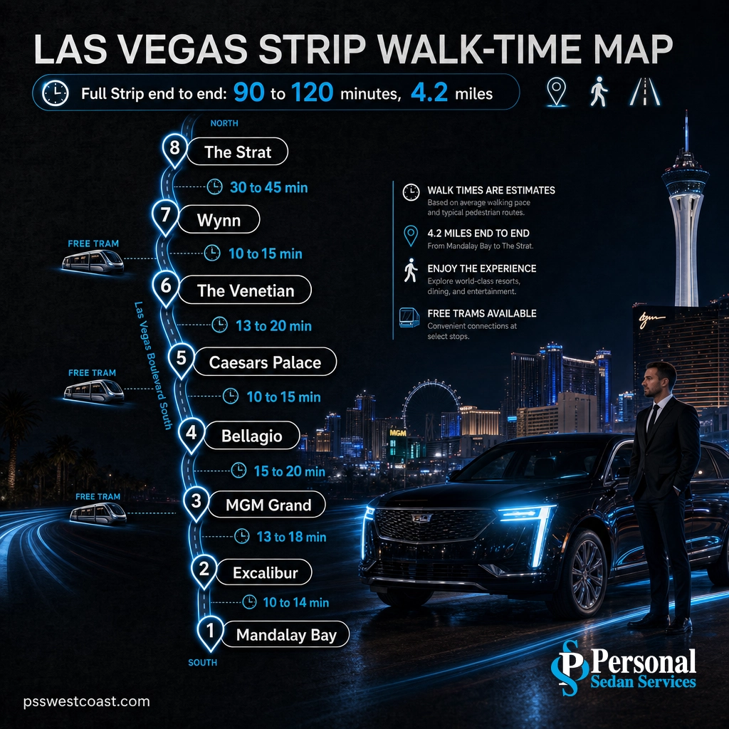
The pattern is clear once you see it laid out: the center of the Strip, roughly from Park MGM up to the Venetian, is dense and genuinely walkable, while the far north and far south ends stretch out with big gaps. The core walkable cluster, from Bellagio to the Caesars area, is only about 1.5 miles and takes 25 to 30 minutes at a brisk pace. It is the long hops at each end that eat your afternoon.
Walk time for key Strip stretches (minutes, steady pace)
Typical walking times compiled from Las Vegas walking guides. Trams and rideshare cut the long hops sharply.
Strip vs. Las Vegas Boulevard vs. Downtown
The single most common mix-up is treating “the Strip,” “Las Vegas Boulevard,” and “Downtown Las Vegas” as the same place. They are related but distinct, and knowing the difference saves you a wrong-direction ride.
| The Las Vegas Strip | Las Vegas Boulevard | Downtown / Fremont Street | |
|---|---|---|---|
| What it is | The 4.2-mile resort corridor | The full road the Strip sits on | The original city center |
| Length | About 4.2 miles | Much longer, runs across the valley | A compact few blocks |
| Where | Paradise and Winchester (Clark County) | Runs through the county and the city | Inside the city of Las Vegas |
| Known for | Bellagio, Caesars, the Venetian, MGM | The whole boulevard, sign to sign | Fremont Street Experience, older casinos |
| Relation to the Strip | The corridor itself | The road it sits on | About 4 miles north of the Strip |
In short: the Strip is a 4.2-mile section of Las Vegas Boulevard, and Downtown (with Fremont Street) is a separate district about four miles farther north, inside the actual city limits. If you are staying on the Strip and want the old-school Fremont Street vibe, that is a short drive, not a walk.
Should You Walk the Strip or Ride?
Walking is the best way to experience the dense center of the Strip. For the long hops at either end, and for anyone traveling with a group, luggage, kids, heels, or a schedule, riding wins. Here are the realistic options:
- Free resort trams: Two free trams cover useful stretches. One links Mandalay Bay, Luxor, and Excalibur on the south end. The Aria Express runs between Park MGM, Aria, and Bellagio in the center. Both are free and skip the sidewalk crowds.
- Las Vegas Monorail: A paid line running along the east side of the Strip, from the MGM Grand area up to the Sahara, with stops at several convention and resort points. Useful if your stops line up with its stations.
- Rideshare and taxis: Everywhere, but surge pricing, event traffic, and long resort rideshare pickup zones can turn a quick hop into a slow, unpredictable one, especially on big event nights.
- Private car service: A chauffeured sedan or SUV picks you up at the door, tracks your timing, and handles the whole night without you standing in a pickup line or walking in the heat. For groups and events it is often the simplest option of all.
This is where local knowledge matters. On a normal day, walking the center and riding the ends is the smart mix. On a peak event weekend, when a race, a fight, a residency, or a convention shuts down lanes and packs the sidewalks, the Strip’s 4.2 miles can crawl. A driver who knows which side streets and back-of-house routes still move is the difference between making your reservation and missing it.
Get Around the Strip in Comfort: Local Car Service
Personal Sedan Services is Las Vegas’s top-rated luxury transportation, a perfect 5.0 Google rating from more than 900 reviews, with licensed, background-checked, bare-headed professional chauffeurs. Whether you need an airport pickup straight to your hotel, hotel-to-hotel rides for a group, or a car for the full night, we handle the logistics so you do not have to walk four miles in the desert sun. Explore our luxury transportation services or see the full fleet of sedans, SUVs, and vans.
Tips for Getting Around the Strip
- Time your walk. Early morning and after sunset are far more comfortable than midday, especially May through September.
- Use the pedestrian bridges. At the major intersections you cross above the traffic on escalator bridges rather than at street level. They add a few minutes but are safer and often faster.
- Cut through, not around. On the dense center stretch, walking through a resort’s climate-controlled interior beats baking on the sidewalk, just budget the extra interior distance.
- Wear real shoes. Four miles of concrete is a lot. This is not the night for brand-new dress shoes.
- Plan the airport leg. Harry Reid International Airport sits just east of the south Strip. It is close, but rideshare lines and resort traffic can be slow, so a scheduled pickup gets you from the gate to your room fastest. See our Las Vegas airport shuttle service.
- Match the ride to the group. Two people can walk and tram the center easily. Six people heading to dinner and a show are better off in one vehicle than spread across three rideshares.
For a full breakdown of every option, from the Deuce bus to the monorail to a private car, see our guide to the best ways to get around Las Vegas.
Common Questions About the Length of the Strip
How long is the Las Vegas Strip?
How long does it take to walk the Las Vegas Strip?
Is the Las Vegas Strip inside the city of Las Vegas?
Where does the Las Vegas Strip start and end?
What is the easiest way to get around the Strip without walking?
Related Las Vegas Guides
- The Best Ways to Get Around Las Vegas: every option, from the Deuce to a private car, compared side by side.
- How to Get to the Sphere: routes, parking, and the fastest ways in.
- The Best Hotels in Las Vegas: top luxury picks up and down the Strip.
- Best Restaurants on the Strip: where to eat along the 4.2 miles.
- Best Casinos in Las Vegas: the marquee floors worth planning around.
Sources and Methodology
Length, boundaries, and location facts are drawn from published references on the Las Vegas Strip and Las Vegas Boulevard. The July temperature figure is the NOAA U.S. Climate Normals (1991–2020) average high for Las Vegas. Walking times are typical estimates compiled from established Las Vegas walking guides and reflect a steady pace before crowds and casino interiors; real times vary with your pace, stops, and the day’s events.