


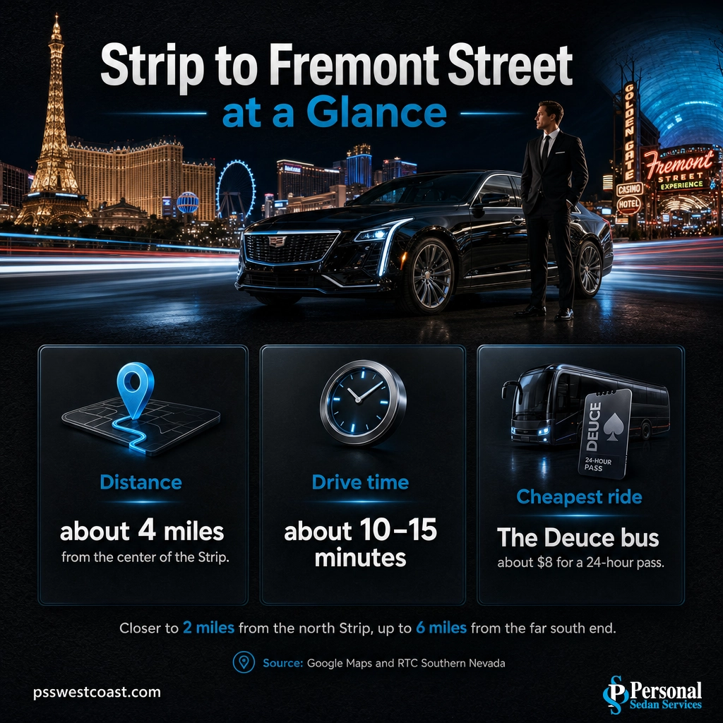
Quick answer: The Fremont Street Experience in downtown Las Vegas is about 4 miles from the center of the Strip, roughly a 10 to 15 minute drive straight up Las Vegas Boulevard or Interstate 15. From the north end of the Strip near the STRAT it is only about 2 miles, and from the far south end near Mandalay Bay it stretches to about 6 miles. It is close enough to do both in one night, but too far to walk comfortably from most Strip hotels.
If you are searching “how far is Fremont Street from the Strip,” you are almost always planning to see both: the resort corridor of the Strip and the neon canopy and old-school casinos of downtown Las Vegas. The good news is they are close. Fremont Street sits about 4 miles north of the heart of the Strip, roughly a 10 to 15 minute drive up Las Vegas Boulevard. The catch is that “close” in Las Vegas still means too far to walk in the heat, and the drive runs through some of the busiest, most stop-and-go blocks in the city. Here is exactly how far it is, every real way to get there, and how to bounce between the two without fighting traffic or surge pricing.
- Distance: about 4 miles from the center of the Strip to the Fremont Street Experience, closer to 2 miles from the north end and up to 6 miles from the far south end.
- Drive time: about 10 to 15 minutes in light traffic (20-plus on busy Strip nights) up Las Vegas Boulevard, or via Interstate 15 to the US-95 downtown exit when the Boulevard is jammed.
- Walking: realistic only from the north Strip, about 30 to 40 minutes from the STRAT. From the center or south Strip it is a long, hot 4 to 6 mile walk.
- Transit: the Monorail does not reach downtown. The RTC Deuce bus does, 24 hours a day, but it is slow because it stops at every resort.
- For a group doing both ends in one night, a private chauffeured ride skips the parking, the surge pricing, and the 2 a.m. scramble for a car back to your hotel.

What’s in This Guide
- How Far Is Fremont Street from the Strip, Exactly?
- Ways to Get from the Strip to Fremont Street
- The Drive: Best Route and What to Expect
- What’s Between the Strip and Downtown
- Can You Do the Strip and Fremont Street in One Night?
- Skip the Surge: Let Us Take You Both Ways
- Frequently Asked Questions
- Related Las Vegas Travel Guides
How Far Is Fremont Street from the Strip, Exactly?
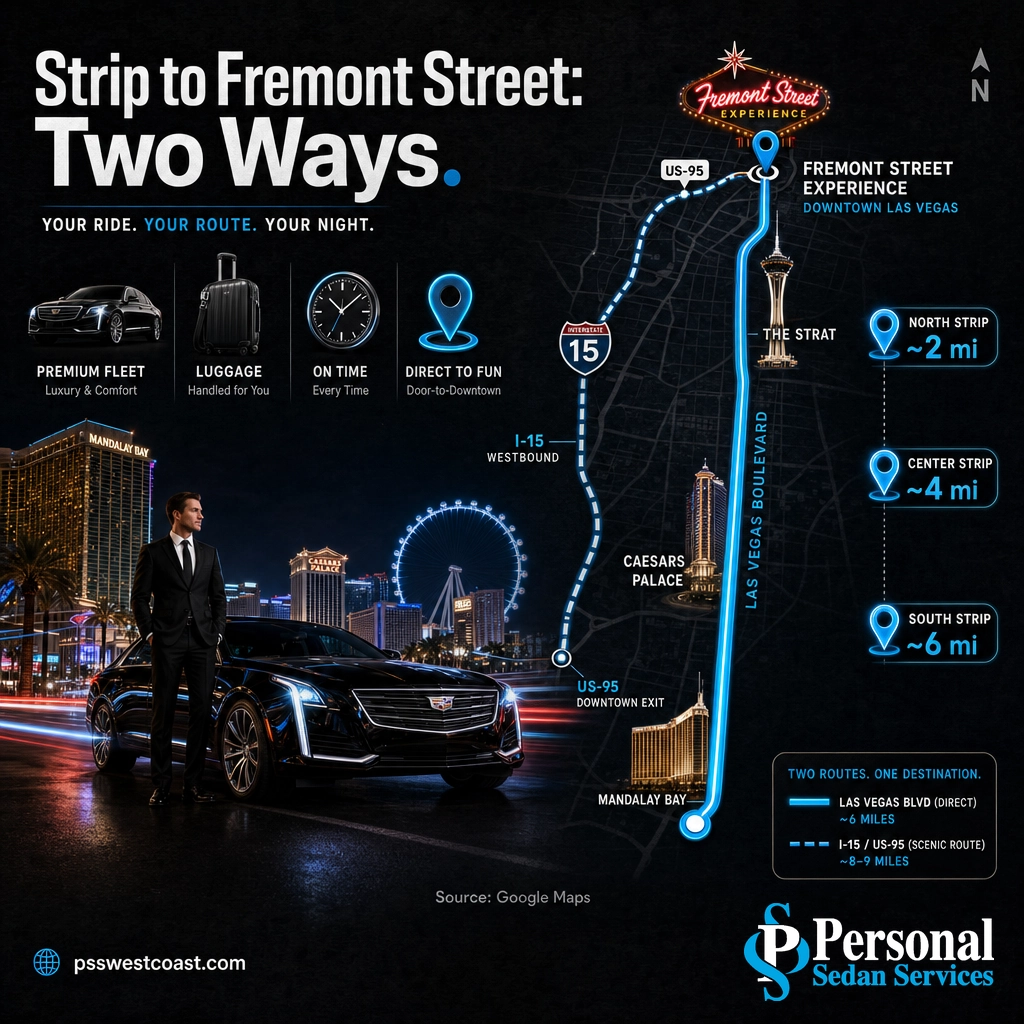
There is no single number, because the Strip is more than 4 miles long and Fremont Street sits just off its north end in downtown Las Vegas. Where you start changes the answer. The honest way to say it: the Fremont Street Experience is about 4 miles from the center of the Strip, the stretch around Caesars Palace, the Bellagio, and the LINQ. From the north end near the STRAT it is only about 2 miles, and from the far south end near Mandalay Bay it climbs to roughly 6 miles. In driving time, that is usually a 10 to 15 minute trip from the middle of the Strip, longer when Las Vegas Boulevard is crawling.
| Starting point on the Strip | Distance to Fremont Street | Typical drive time |
|---|---|---|
| North Strip (STRAT, Sahara) | ~2 miles | ~6 to 8 min |
| Center Strip (Caesars, Bellagio, LINQ) | ~4 miles | ~10 to 15 min |
| South Strip (MGM Grand, Mandalay Bay) | ~6 miles | ~13 to 20 min |
Because the two districts sit so close, the real question is not whether to go, it is how. Driving yourself, riding the bus, calling a rideshare, and booking a private car are all on the table, and they are not equally good once you factor in parking, surge pricing, and the trip back.
Source: Google Maps driving directions, Las Vegas Strip to Fremont Street
Ways to Get from the Strip to Fremont Street
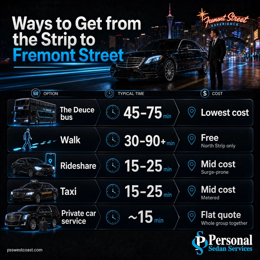
Four miles in Las Vegas is an awkward distance. It is too far to walk from most hotels, short enough that a long rideshare fare feels like a waste, and busy enough that the cheap bus is slow. Here is an honest look at every option that actually works, from cheapest to most comfortable.
| Option | Time | Rough cost | Best for |
|---|---|---|---|
| The Deuce (RTC bus) | ~45 to 75 min | $ (lowest) | Budget travelers with time to spare. Runs 24 hours but stops at every Strip resort. |
| Walk | ~30 to 90+ min | Free | Only realistic from the north Strip. A long, hot haul from the center or south. |
| Rideshare (Uber or Lyft) | ~15 to 25 min | $$ (surge-prone) | Quick when prices are normal, but fares spike on weekend and late nights, and pickup zones are a walk. |
| Taxi | ~15 to 25 min | $$ (metered) | Easy from any resort taxi line, no app needed. Costs more than the bus, less drama than surge. |
| Private car service (us) | ~15 min | $$ flat quote | Groups and full-night plans. A chauffeur waits, your whole party rides together, and the price is set up front. |
One option people expect to work but does not: the Las Vegas Monorail. It runs along the east side of the Strip between the MGM Grand and the Sahara, and it never reaches downtown, so it is useless for getting to Fremont Street. The RTC Deuce, the double-decker bus that runs the length of the Strip, does continue north to the Downtown Transit Center, a short walk from the Fremont Street Experience. It is the cheapest ride in town, around $8 for a 24-hour pass, but it stops at nearly every resort, so a 4-mile trip can take over an hour on a busy night.
Transit note: The old Strip & Downtown Express (SDX), a faster limited-stop route, was suspended during the pandemic and has not returned, so the Deuce is the RTC bus to catch today. Fares change, so confirm the current pass price with the Regional Transportation Commission before you ride.
See our local Las Vegas transportation
Source: Regional Transportation Commission of Southern Nevada, transit fares and routes | Las Vegas Monorail official station map
The Drive: Best Route and What to Expect
There are two sensible ways to cover the 4 miles, and which one wins depends entirely on traffic.
- Straight up Las Vegas Boulevard. The scenic way. You pass the full north Strip, the STRAT, the Sahara, the old neon of the Arts District, and roll right into Fremont East downtown. It is the shortest route by distance, but it is also the most stop-and-go, with heavy pedestrian traffic and lights at every block. Great by day, slow on a packed night.
- Interstate 15 to the US-95 downtown exit. The fast way when the Boulevard is jammed. Hop on I-15 north, take US-95 toward downtown, and exit near Fremont. You skip the Strip crawl entirely, which on a busy Friday or Saturday can save 10 minutes or more.
Distance to Fremont Street by Where You Start on the Strip
Approximate driving distance from each part of the Strip to the Fremont Street Experience. Source: Google Maps estimates.
Parking reality: Downtown parking is real but it fills fast on weekends and event nights, and many Fremont Street garages charge or require validation. If you drive yourself, you also inherit the two worst parts of a night out downtown: hunting for a space when you arrive, and driving back to the Strip after a few drinks. Neither is a good look at 1 a.m. in a strange part of town.
Las Vegas car service across the valley
What’s Between the Strip and Downtown
The 4 miles from the center of the Strip to Fremont Street are not empty. Las Vegas Boulevard links the two through the parts of town locals know best, and a few are worth a stop if you are not in a hurry.
- The north Strip. Past the LINQ and the Sahara you reach the STRAT, the tower that marks the unofficial end of the Strip and the start of the run into downtown. From here, downtown is only about 2 miles.
- The Arts District (18b). The stretch of Main Street and the surrounding blocks just south of downtown, packed with galleries, vintage shops, breweries, and some of the city’s best independent restaurants. It is the most interesting thing on the drive and a favorite with locals.
- Fremont East. The blocks just past the neon canopy, home to the Container Park, craft cocktail bars, and the newer downtown nightlife scene, a more grown-up counterpart to the casinos under the lights.
Local tip: If you have never seen the Las Vegas Arts District, build 30 minutes into the trip and treat the ride downtown as part of the night rather than dead time between two destinations. A private driver makes that easy, since you can stop, look, and move on without re-parking.
Source: Fremont Street Experience official site
Ride downtown with a private chauffeur

Can You Do the Strip and Fremont Street in One Night?
Yes, and plenty of visitors do. The two districts are close enough that a lot of Las Vegas trips include dinner and a show on the Strip, then the neon canopy, zip line, and old-school casinos of Fremont Street later the same night. The distance is not the problem. The logistics are.
The one-night math: A round trip between the mid-Strip and Fremont Street is only about 8 miles and 30 minutes of total driving. The time that actually eats your night is everything around the drive, finding and paying for parking at both ends, waiting out a rideshare surge when the Fremont bars let out, and splitting a group of six across two cars because one Uber will not fit everyone.
That is why doing both ends well comes down to the ride, not the mileage. When someone else is driving, Fremont Street stops being a separate trip you have to plan and becomes a simple second stop on the same night. You get dropped at the door, picked up at the door, and nobody has to stay sober to drive back to the Strip.
Skip the Surge: Let Us Take You Both Ways
The pain of getting between the Strip and Fremont Street is never the 4 miles. It is the parking you cannot find, the surge pricing that doubles your fare at midnight, the group that will not fit in one rideshare, and the long wait for a car back to your hotel when downtown empties out at 2 a.m. The whole SERP will tell you the distance. Almost none of it tells you how to do the trip without that hassle.
A private chauffeured ride takes all of it off your plate. One professional driver in a clean, late-model sedan, SUV, or van keeps your whole party together, drops you at the Fremont Street Experience door, and is waiting when you are ready to head back, no app, no surge, no 2 a.m. scramble. For a group doing both ends in one night, it is cheaper and far less stressful than two or three separate rideshares each way.
Explore group transportation for your night out
Personal Sedan Services runs the Strip and downtown Las Vegas every night, with licensed, background-checked chauffeurs and a perfect 5.0 Google rating from more than 900 reviews. We will take you from your Strip hotel to Fremont Street, wait or come back on your schedule, and get your whole group home safely, however late the night runs.
Book your Strip to Fremont Street ride
Frequently Asked Questions
How far is Fremont Street from the Las Vegas Strip?
How long does it take to get from the Strip to Fremont Street?
Can you walk from the Strip to Fremont Street?
Does the Las Vegas Monorail go to Fremont Street?
What is the cheapest way to get from the Strip to Fremont Street?
Related Las Vegas Travel Guides
- How long the Las Vegas Strip is – the length, map, and real walk times that explain why 4 miles feels so far.
- How far Red Rock Canyon is from Las Vegas – the short desert escape just west of the Strip.
- How far Area 51 is from Las Vegas – the famous day-trip drive north of the city.
- How far Arizona is from Las Vegas – the drive east toward the Grand Canyon state.
- Is there a free shuttle from the airport to Strip hotels? – how to get from the airport to your hotel before the night begins.
- Best off-Strip restaurants in Las Vegas – including the downtown and Arts District spots on the way to Fremont.
Sources and Methodology
Driving distances and times from the Las Vegas Strip to the Fremont Street Experience are approximate, based on Google Maps directions, and vary with the exact starting hotel and with Las Vegas Boulevard traffic. Because the Strip runs more than 4 miles end to end, the distance to downtown is given by section: about 2 miles from the north end near the STRAT, about 4 miles from the center, and about 6 miles from the far south end near Mandalay Bay. Transit details, including the Deuce route, 24-hour service, and fares, reference the Regional Transportation Commission of Southern Nevada; fares change, so confirm current pass prices before riding. The Strip & Downtown Express (SDX) was suspended during the COVID-19 pandemic and has not returned. Monorail route and station information references the Las Vegas Monorail official site; the Monorail does not serve downtown. Fremont Street details reference the Fremont Street Experience official site.
