


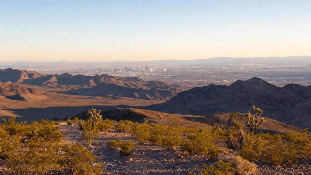
What desert is Las Vegas in? Las Vegas sits in the Mojave Desert, the smallest and driest of North America’s four major deserts. The Mojave spreads across parts of Nevada, California, Arizona, and Utah, and Las Vegas is its largest city. It is high desert: rocky valleys, rugged mountains, and Joshua trees, not endless sand dunes.
Stand on the Strip and it is easy to forget you are in a desert at all. But Las Vegas sits squarely inside the Mojave, the driest desert on the continent, surrounded by bare mountain ranges, open scrubland, and some of the most extreme terrain in the United States. The Mojave is why the city stays so sunny, why the nearby landscape swings from a snowcapped 11,916-foot peak to the lowest, hottest point in North America, and, in a roundabout way, why a city exists here at all. Here is exactly which desert Las Vegas is in, what makes the Mojave different from its neighbors, and how to make the most of the desert that surrounds the neon.
- The short answer: Las Vegas is in the Mojave Desert, the smallest and driest of the four North American deserts.
- Which Mojave: the city is the largest urban area in the desert that spans southern Nevada, southeastern California, and slivers of Arizona and Utah.
- What it looks like: high desert, not the Sahara. The valley floor sits near 2,000 feet with rocky mountains, creosote, and Joshua trees, and gets only about 4 inches of rain a year.
- A land of extremes: within a couple of hours lie Badwater Basin at 282 feet below sea level, Death Valley’s 134-degree world record, and Charleston Peak at 11,916 feet, all in the Mojave.
- Why a city is here: spring-fed meadows on the desert floor gave Las Vegas its name, Spanish for “the meadows.”
- Getting around: desert distances and heat are deceptive. For a day trip out to Red Rock, Valley of Fire, or Death Valley, a professional chauffeur beats driving an unfamiliar rental or chasing a rideshare into the backcountry.

What’s in This Guide
- So, What Desert Is Las Vegas In?
- The Mojave Desert, Explained
- Mojave vs. the Other North American Deserts
- Why the Mojave Is a Land of Extremes
- Why Is There a City in the Middle of the Desert?
- Exploring the Mojave Around Las Vegas
- Getting Around the Desert
- Frequently Asked Questions
- Related Las Vegas Guides
So, What Desert Is Las Vegas In?
Las Vegas is in the Mojave Desert. The whole valley, the Strip, the suburbs, the airport, and the mountains you see on the horizon all sit within it. The Mojave is one of the four major deserts of North America, and it is the one that covers southern Nevada, dipping into southeastern California and reaching small distances into Arizona and Utah. Las Vegas is by far the largest city anywhere in it.
If you want the authoritative version, the land just outside town tells the story. The Mojave National Preserve managed by the National Park Service protects a huge stretch of this desert in California, and Red Rock Canyon on the west edge of Las Vegas is classic Mojave terrain. The city grew up in the middle of the desert, not next to it.
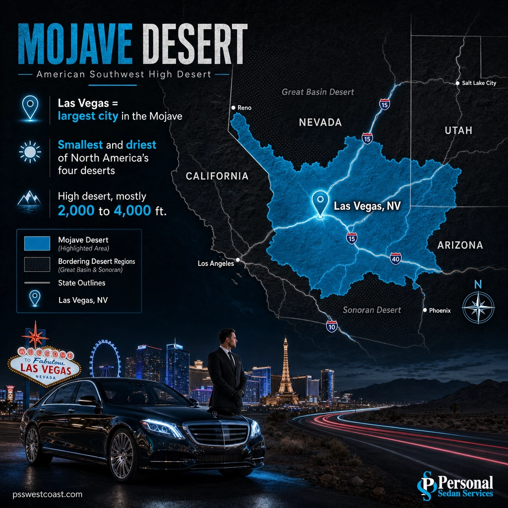
People sometimes assume Las Vegas is in the Sonoran Desert because they picture saguaro cactus and Phoenix heat, or in some generic “Nevada desert.” Neither is right. The saguaro belongs to the Sonoran Desert well to the south, and while Nevada does hold more than one desert, the Las Vegas valley specifically is Mojave country.
Source: Mojave Desert overview and boundaries | National Park Service: Mojave National Preserve
The Mojave Desert, Explained
The Mojave is defined less by sand than by elevation, dryness, and one unmistakable plant. It is a high desert, meaning most of it sits well above sea level rather than at the low, sandy elevations people imagine. According to the Mojave Desert overview, most of the desert lies between 2,000 and 4,000 feet, and the Las Vegas valley floor sits right at the bottom of that range, around 2,000 feet.
It is also the driest desert on the continent. The Mojave receives an annual average of just 2 to 6 inches of precipitation, and Las Vegas lands near the middle of that at about 4 inches a year, with roughly 210 clear days. That combination of thin rainfall and high sunshine is exactly what makes the valley feel so arid and bright.
The plant that tells you for certain you are in the Mojave is the Joshua tree (Yucca brevifolia), a spiky, branching yucca that is endemic to this desert and grows almost nowhere else on Earth. Where you see Joshua trees, you are in the Mojave. Alongside them, low creosote bush, blackbrush, and Mojave yucca blanket the valleys, and bighorn sheep, desert tortoises, and roadrunners live among them. This is a living desert, not a dead one.
Where the Mojave sits between its neighbors: think of it as the middle desert. To the north and east is the Great Basin Desert, higher and colder, where winters bring real snow. To the south is the Sonoran Desert, lower and hotter, where saguaro cactus grow. The Mojave is the transition zone between them, which is part of why the Las Vegas region can swing from alpine snow to record heat within a short drive.
Measuring the Mojave’s exact size is surprisingly hard, because its edges blur into those neighboring deserts. Published estimates range from roughly 31,000 to more than 50,000 square miles depending on where the boundaries are drawn. However you count it, it is the smallest of the four North American deserts, and the driest.
Source: Mojave Desert: elevation, size, precipitation, and the Joshua tree | National Weather Service Las Vegas climate records
Mojave vs. the Other North American Deserts
The single most common mix-up is confusing the Mojave with the other deserts of the American Southwest. There are four, and each has its own climate, size, and signature plant. Knowing which is which makes it obvious why Las Vegas belongs to the Mojave and not its neighbors.
| Desert | Main location | Character | Signature plant | Near Las Vegas? |
|---|---|---|---|---|
| Mojave | S. Nevada, SE California, edges of AZ and UT | Smallest and driest; high desert, 2 to 6 in rain | Joshua tree | Las Vegas sits inside it |
| Great Basin | Most of Nevada, Utah, parts of OR and ID | The largest U.S. desert; a cold desert with snowy winters | Sagebrush | Borders the Mojave to the north |
| Sonoran | S. Arizona, SE California, NW Mexico | Hot, with two rainy seasons and lush growth | Saguaro cactus | Borders the Mojave to the south |
| Chihuahuan | W. Texas, New Mexico, northern Mexico | Largest in North America; higher, with summer rain | Agave and creosote | Far to the southeast, not near Vegas |
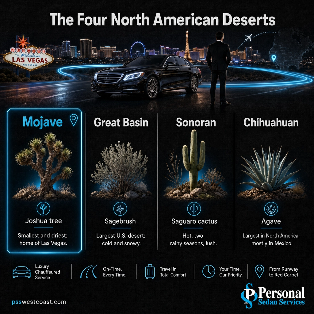
The practical takeaways for a Las Vegas visitor: if you see sagebrush and snow as you drive north toward Reno, you have crossed into the Great Basin. If you see saguaro cactus as you drive south toward Phoenix, you have dropped into the Sonoran. And when you are in the valley itself, among Joshua trees and red rock, you are in the Mojave.
The Mojave is not a sea of sand dunes. The biggest misconception about “the desert” is the Sahara image of rolling dunes to the horizon. Real Mojave scenery is mostly rocky: open valleys of low scrub, dramatic bare mountains, and canyons of banded sandstone like Red Rock and Valley of Fire. Sand dunes do exist in a few corners of the desert, but they are the exception, not the rule. Expect rugged high country, not a beach without an ocean.
Source: Mojave Desert: comparison with the Great Basin, Sonoran, and Chihuahuan deserts
Why the Mojave Is a Land of Extremes
The Mojave around Las Vegas holds some of the most extreme geography on the planet, and the city sits right in the middle of it. Within a two-hour radius you can go from the lowest point in North America to a peak almost 12,000 feet high, and pass through the hottest reliably measured place on Earth along the way.
The hot end is Death Valley, which sits in the northern Mojave. Its Badwater Basin bottoms out at 282 feet below sea level, the lowest point in North America. And on July 10, 1913, Furnace Creek in Death Valley recorded 134 degrees Fahrenheit, which the National Park Service cites as the hottest air temperature reliably recorded anywhere on Earth. That record-breaking furnace is part of the same desert as the Strip.
The cold, high end is just as surprising. Northwest of the Strip, the Spring Mountains rise nearly two vertical miles above the desert floor to Charleston Peak at 11,916 feet, the eighth-highest summit in Nevada. It wears snow for much of the year and hosts southern Nevada’s only ski area. So the same desert that holds Earth’s heat record also holds a genuine alpine zone, about 45 minutes apart.

This range is the real answer to why the Las Vegas region feels like several worlds at once. The valley floor is warm Mojave scrub, the canyons just outside town are red sandstone, the peaks to the northwest are forested and snowy, and the basin to the northwest is a below-sea-level oven. All of it is the Mojave Desert.
Source: National Park Service: Death Valley facts and records

Why Is There a City in the Middle of the Desert?
If the Mojave is the driest desert on the continent, why build a major city in it? The answer, fittingly, is water. Long before the casinos, this spot on the desert floor had something rare: natural artesian springs that fed green, grassy meadows in the middle of the arid basin.
Those meadows gave the city its name. In 1829, members of a Spanish trading party traveling the Old Spanish Trail stopped at the spring-fed grassland and called it Las Vegas, Spanish for “the meadows.” The springs made the site a crucial watering stop between New Mexico and California, and the reliable water later drew the railroad, which founded the modern town in 1905. Native Paiute people had relied on the same springs for generations before that.
From meadows to metropolis: the original springs were eventually drained and the meadows vanished as the city grew, but the name stuck. Modern Las Vegas now draws most of its water from the Colorado River through Lake Mead rather than those first desert springs, but the city exists today because, in the heart of the driest desert in North America, this one spot happened to have water.
Source: History of Las Vegas: the springs, the name, and the founding
Exploring the Mojave Around Las Vegas
One of the best parts of visiting Las Vegas is that the Mojave is right there, and it is spectacular. You do not have to go far to trade the neon for red canyons, Joshua tree forests, or snow. A few of the standout stops in the desert around the city:
- Red Rock Canyon National Conservation Area (about 20 miles west): a 13-mile scenic loop through towering red and tan sandstone cliffs, classic Mojave at its most photogenic, and the closest big nature to the Strip.
- Valley of Fire State Park (about 50 miles northeast): Nevada’s oldest state park, full of brilliant red Aztec sandstone formations, slot canyons, and ancient petroglyphs.
- Mount Charleston and Lee Canyon (about 35 to 45 miles northwest): the cool, forested high country of the Spring Mountains, with hiking in summer and southern Nevada’s only ski resort in winter.
- Death Valley National Park (about 120 miles west): the hottest, lowest, driest place in North America, and one of the most otherworldly landscapes in the country.
Every one of these sits in the Mojave, and together they show how much variety a single desert can hold. For a deeper rundown of where to go, our guide to the best day trips from Las Vegas maps out the drives worth taking, and how far Death Valley is from Las Vegas covers the route to the desert’s most extreme corner.
See our Las Vegas attractions transportation
Getting Around the Desert
The Mojave is beautiful, but it is still a desert, and desert distances and heat catch visitors off guard. A drive that looks short on a map runs through open country with little shade, few services, and summer temperatures that can climb past 115 degrees on the valley floor and far higher in Death Valley. Cell service drops out, and rideshare apps are unreliable or unavailable once you leave the metro area.
That is exactly where a professional car service earns its place. For a day out to Red Rock, Valley of Fire, Mount Charleston, or Death Valley, a licensed, background-checked chauffeur in a comfortable, well-maintained vehicle means you can relax and take in the scenery instead of navigating unfamiliar desert roads, and your whole group stays together. Personal Sedan Services is Las Vegas’s top-rated luxury transportation, with a perfect 5.0 Google rating from more than 900 reviews, and our drivers know the valley and the desert routes around it in every season.
Whether you are staying on the Strip or heading out to explore the Mojave, a reliable local ride takes the heat, the distance, and the driving stress out of the day.
Book Now or Text (702) 248-7706
Explore our luxury transportation options
Frequently Asked Questions
What desert is Las Vegas in?
Is Las Vegas in the Mojave or the Sonoran Desert?
Is the Mojave Desert all sand dunes?
How hot and dry does the Mojave Desert get near Las Vegas?
Why was Las Vegas built in the middle of a desert?
Related Las Vegas Guides
- Does it snow in Las Vegas? – how the same Mojave Desert produces record heat and real mountain snow within one drive.
- Where does Las Vegas get its water? – how the driest desert in North America keeps a major city supplied.
- Is Las Vegas a good place to live? – what desert living in the valley is actually like year-round.
- Best day trips from Las Vegas – the full menu of Mojave and beyond destinations worth the drive.
Book a ride to explore the Mojave
Sources and Methodology
The identification of Las Vegas as part of the Mojave Desert, along with the desert’s elevation range (most of it between 2,000 and 4,000 feet), annual precipitation (2 to 6 inches), size estimates, the Joshua tree as its endemic indicator species, and its position between the Great Basin Desert to the north and the Sonoran Desert to the south, draws on the Mojave Desert geographic overview and the National Park Service’s Mojave National Preserve. Las Vegas climate figures, including the roughly 4 inches of annual rainfall, approximately 210 clear days, and the valley floor near 2,000 feet of elevation, come from the National Weather Service Las Vegas office. Death Valley’s Badwater Basin elevation of 282 feet below sea level (the lowest point in North America) and the 134-degree Fahrenheit reading at Furnace Creek on July 10, 1913 (the hottest reliably recorded temperature on Earth) come from the National Park Service. Charleston Peak’s 11,916-foot elevation and Lee Canyon details come from the resort and long-running regional records. The origin of the name Las Vegas, “the meadows,” and the 1829 and 1905 dates come from the documented history of Las Vegas. Distances and drive times are approximate.
- Mojave Desert: geography, size, elevation, precipitation, and bordering deserts
- National Park Service: Mojave National Preserve
- National Weather Service Las Vegas: climate records and normals
- National Park Service: Death Valley facts and records
- History of Las Vegas: the springs, the name, and the founding
